


Haut-Fays MHL 2025

fra_depoorter
User
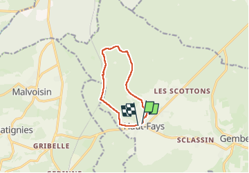

Length
8 km

Max alt
443 m

Uphill gradient
125 m
Km-Effort
9.6 km

Min alt
340 m

Downhill gradient
126 m
Boucle
Yes
Creation date :
2025-02-13 13:00:06.67
Updated on :
2025-02-13 14:57:01.732
1h56
Difficulty : Easy

FREE GPS app for hiking
 SityTrail
IGN / Geographical institutes
SityTrail Plus
The world is yours!
About
Trail Walking of 8 km to be discovered at Wallonia, Luxembourg, Daverdisse. This trail is proposed by fra_depoorter.
Positioning
Country:
Belgium
Region :
Wallonia
Department/Province :
Luxembourg
Municipality :
Daverdisse
Location:
Unknown
Start:(Dec)
Start:(UTM)
644462 ; 5540794 (31U) N.
Comments