


rehon

jcb48
User
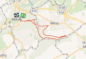

Length
7.1 km

Max alt
357 m

Uphill gradient
174 m
Km-Effort
9.4 km

Min alt
252 m

Downhill gradient
175 m
Boucle
Yes
Creation date :
2025-02-13 13:08:46.498
Updated on :
2025-02-13 15:51:27.134
2h42
Difficulty : Medium

FREE GPS app for hiking
 SityTrail
IGN / Geographical institutes
SityTrail Plus
The world is yours!
About
Trail Walking of 7.1 km to be discovered at Grand Est, Meurthe-et-Moselle, Réhon. This trail is proposed by jcb48.
Description
marche
Positioning
Country:
France
Region :
Grand Est
Department/Province :
Meurthe-et-Moselle
Municipality :
Réhon
Location:
Unknown
Start:(Dec)
Start:(UTM)
699512 ; 5486766 (31U) N.
Comments