


Pierre fonds

Glurps
User
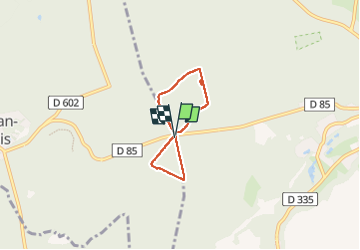

Length
3.9 km

Max alt
146 m

Uphill gradient
45 m
Km-Effort
4.5 km

Min alt
121 m

Downhill gradient
43 m
Boucle
Yes
Creation date :
2025-02-02 12:57:54.0
Updated on :
2025-02-15 08:40:15.299

FREE GPS app for hiking
 SityTrail
IGN / Geographical institutes
SityTrail Plus
The world is yours!
About
Trail of 3.9 km to be discovered at Hauts-de-France, Oise, Pierrefonds. This trail is proposed by Glurps.
Positioning
Country:
France
Region :
Hauts-de-France
Department/Province :
Oise
Municipality :
Pierrefonds
Location:
Unknown
Start:(Dec)
Start:(UTM)
495497 ; 5466016 (31U) N.
Comments