


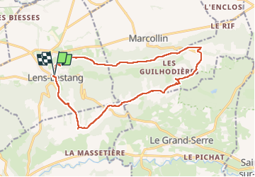
Boucle autour de Lens-Lestang - 16 fév 2025

morganee
User

Length
16.5 km

Max alt
463 m

Uphill gradient
304 m
Km-Effort
21 km

Min alt
291 m

Downhill gradient
302 m
Boucle
Yes
Creation date :
2025-02-16 09:54:27.269
Updated on :
2025-02-16 15:37:38.141
5h42
Difficulty : Easy

FREE GPS app for hiking
 SityTrail
IGN / Geographical institutes
SityTrail Plus
The world is yours!
About
Trail Walking of 16.5 km to be discovered at Auvergne-Rhône-Alpes, Drôme, Lens-Lestang. This trail is proposed by morganee.
Positioning
Country:
France
Region :
Auvergne-Rhône-Alpes
Department/Province :
Drôme
Municipality :
Lens-Lestang
Location:
Unknown
Start:(Dec)
Start:(UTM)
660122 ; 5017484 (31T) N.
Comments