


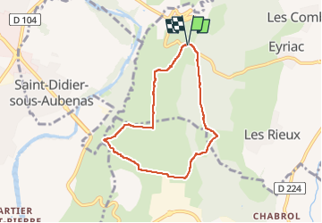
L'Échelette, camp de César , Lavilledieu 17/02/25

Linerou
User

Length
6.6 km

Max alt
368 m

Uphill gradient
106 m
Km-Effort
8 km

Min alt
294 m

Downhill gradient
103 m
Boucle
Yes
Creation date :
2025-02-17 08:17:47.451
Updated on :
2025-02-17 10:25:22.135
1h50
Difficulty : Easy

FREE GPS app for hiking
 SityTrail
IGN / Geographical institutes
SityTrail Plus
The world is yours!
About
Trail Walking of 6.6 km to be discovered at Auvergne-Rhône-Alpes, Ardèche, Lussas. This trail is proposed by Linerou.
Positioning
Country:
France
Region :
Auvergne-Rhône-Alpes
Department/Province :
Ardèche
Municipality :
Lussas
Location:
Unknown
Start:(Dec)
Start:(UTM)
614326 ; 4941098 (31T) N.
Comments