


port lympia

giovannoni
User

Length
8.1 km

Max alt
24 m

Uphill gradient
83 m
Km-Effort
9.2 km

Min alt
0 m

Downhill gradient
95 m
Boucle
No
Creation date :
2025-02-17 08:47:46.658
Updated on :
2025-02-17 11:24:27.375
2h35
Difficulty : Medium

FREE GPS app for hiking
 SityTrail
IGN / Geographical institutes
SityTrail Plus
The world is yours!
About
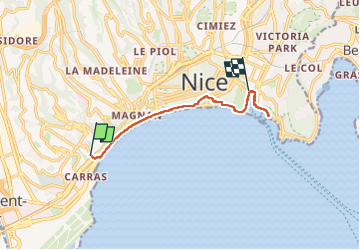
Trail Walking of 8.1 km to be discovered at Provence-Alpes-Côte d'Azur, Maritime Alps, Nice. This trail is proposed by giovannoni.
Positioning
Country:
France
Region :
Provence-Alpes-Côte d'Azur
Department/Province :
Maritime Alps
Municipality :
Nice
Location:
Unknown
Start:(Dec)
Start:(UTM)
357293 ; 4838137 (32T) N.
Comments