


Mad_13_Lourenco

jeanmarcMasson
User GUIDE
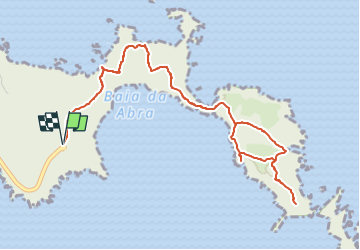

Length
7.5 km

Max alt
136 m

Uphill gradient
479 m
Km-Effort
13.8 km

Min alt
0 m

Downhill gradient
479 m
Boucle
Yes
Creation date :
2025-02-17 20:02:35.814
Updated on :
2025-02-27 08:01:41.884
3h08
Difficulty : Difficult

FREE GPS app for hiking
 SityTrail
IGN / Geographical institutes
SityTrail Plus
The world is yours!
About
Trail Walking of 7.5 km to be discovered at Madeira, Unknown, Caniçal. This trail is proposed by jeanmarcMasson.
Points of interest


Positioning
Country:
Portugal
Region :
Madeira
Department/Province :
Unknown
Municipality :
Caniçal
Location:
Unknown
Start:(Dec)
Start:(UTM)
340631 ; 3624115 (28S) N.
Comments