


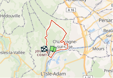
Les hauts de champagne

avdem
User

Length
9.3 km

Max alt
133 m

Uphill gradient
147 m
Km-Effort
11.3 km

Min alt
20 m

Downhill gradient
147 m
Boucle
Yes
Creation date :
2025-02-18 07:52:44.384
Updated on :
2025-02-18 10:32:25.041
2h38
Difficulty : Medium

FREE GPS app for hiking
 SityTrail
IGN / Geographical institutes
SityTrail Plus
The world is yours!
About
Trail Walking of 9.3 km to be discovered at Ile-de-France, Val-d'Oise, Parmain. This trail is proposed by avdem.
Description
Facile
Positioning
Country:
France
Region :
Ile-de-France
Department/Province :
Val-d'Oise
Municipality :
Parmain
Location:
Unknown
Start:(Dec)
Start:(UTM)
442650 ; 5441684 (31U) N.
Comments