


Mont Cima - Croix de Cuor

giovannoni
User
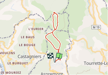

Length
6.3 km

Max alt
867 m

Uphill gradient
316 m
Km-Effort
10.5 km

Min alt
567 m

Downhill gradient
317 m
Boucle
Yes
Creation date :
2025-02-18 12:15:16.783
Updated on :
2025-02-18 12:15:18.501
2h23
Difficulty : Medium

FREE GPS app for hiking
 SityTrail
IGN / Geographical institutes
SityTrail Plus
The world is yours!
About
Trail Walking of 6.3 km to be discovered at Provence-Alpes-Côte d'Azur, Maritime Alps, Aspremont. This trail is proposed by giovannoni.
Positioning
Country:
France
Region :
Provence-Alpes-Côte d'Azur
Department/Province :
Maritime Alps
Municipality :
Aspremont
Location:
Unknown
Start:(Dec)
Start:(UTM)
358871 ; 4849835 (32T) N.
Comments