


Boucle PORNIC - 10km

jeanmarcMasson
User GUIDE
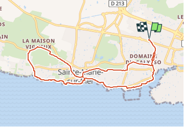

Length
10.1 km

Max alt
41 m

Uphill gradient
112 m
Km-Effort
11.6 km

Min alt
1 m

Downhill gradient
111 m
Boucle
Yes
Creation date :
2025-02-18 18:39:08.619
Updated on :
2025-02-18 18:48:46.461
2h38
Difficulty : Medium

FREE GPS app for hiking
 SityTrail
IGN / Geographical institutes
SityTrail Plus
The world is yours!
About
Trail Walking of 10.1 km to be discovered at Pays de la Loire, Loire-Atlantique, Pornic. This trail is proposed by jeanmarcMasson.
Positioning
Country:
France
Region :
Pays de la Loire
Department/Province :
Loire-Atlantique
Municipality :
Pornic
Location:
Unknown
Start:(Dec)
Start:(UTM)
567660 ; 5219063 (30T) N.
Comments