


cresson. + roche percée

philou68
User

Length
17.9 km

Max alt
342 m

Uphill gradient
626 m
Km-Effort
26 km

Min alt
127 m

Downhill gradient
625 m
Boucle
Yes
Creation date :
2025-02-19 08:11:14.464
Updated on :
2025-02-19 14:25:11.01
6h11
Difficulty : Easy

FREE GPS app for hiking
 SityTrail
IGN / Geographical institutes
SityTrail Plus
The world is yours!
About
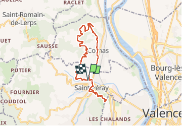
Trail Walking of 17.9 km to be discovered at Auvergne-Rhône-Alpes, Ardèche, Saint-Péray. This trail is proposed by philou68.
Positioning
Country:
France
Region :
Auvergne-Rhône-Alpes
Department/Province :
Ardèche
Municipality :
Saint-Péray
Location:
Unknown
Start:(Dec)
Start:(UTM)
645218 ; 4978932 (31T) N.
Comments