


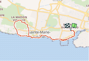
Rando Pornic

jeanmarcMasson
User GUIDE

Length
10.4 km

Max alt
32 m

Uphill gradient
115 m
Km-Effort
11.9 km

Min alt
1 m

Downhill gradient
115 m
Boucle
Yes
Creation date :
2025-02-19 11:02:43.359
Updated on :
2025-02-19 14:36:30.371
2h21
Difficulty : Medium

FREE GPS app for hiking
 SityTrail
IGN / Geographical institutes
SityTrail Plus
The world is yours!
About
Trail Walking of 10.4 km to be discovered at Pays de la Loire, Loire-Atlantique, Pornic. This trail is proposed by jeanmarcMasson.
Positioning
Country:
France
Region :
Pays de la Loire
Department/Province :
Loire-Atlantique
Municipality :
Pornic
Location:
Unknown
Start:(Dec)
Start:(UTM)
567557 ; 5218264 (30T) N.
Comments