


montigny 20.2.2025

jcb48
User
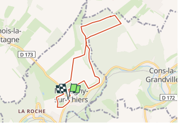

Length
7.7 km

Max alt
358 m

Uphill gradient
113 m
Km-Effort
9.2 km

Min alt
283 m

Downhill gradient
116 m
Boucle
Yes
Creation date :
2025-02-19 16:28:21.366
Updated on :
2025-02-19 16:29:30.4
2h05
Difficulty : Easy

FREE GPS app for hiking
 SityTrail
IGN / Geographical institutes
SityTrail Plus
The world is yours!
About
Trail On foot of 7.7 km to be discovered at Grand Est, Meurthe-et-Moselle, Montigny-sur-Chiers. This trail is proposed by jcb48.
Description
marche
Positioning
Country:
France
Region :
Grand Est
Department/Province :
Meurthe-et-Moselle
Municipality :
Montigny-sur-Chiers
Location:
Unknown
Start:(Dec)
Start:(UTM)
693350 ; 5484174 (31U) N.
Comments