
Bruno070615marche

maginot
User
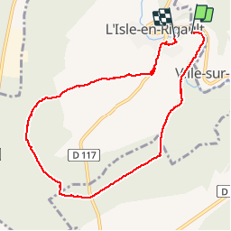

Length
8.6 km

Max alt
244 m

Uphill gradient
102 m
Km-Effort
9.9 km

Min alt
167 m

Downhill gradient
106 m
Boucle
No
Creation date :
2015-06-21 00:00:00.0
Updated on :
2015-06-21 00:00:00.0
1h53
Difficulty : Easy

FREE GPS app for hiking
 SityTrail
IGN / Geographical institutes
SityTrail Plus
The world is yours!
About
Trail Walking of 8.6 km to be discovered at Grand Est, Meuse, L'Isle-en-Rigault. This trail is proposed by maginot.
Description
Temps idéal ,parcours connu mais toujours agréable et facile
Photos


Positioning
Country:
France
Region :
Grand Est
Department/Province :
Meuse
Municipality :
L'Isle-en-Rigault
Location:
Unknown
Start:(Dec)
Start:(UTM)
651004 ; 5398070 (31U) N.
Comments