


Le Champs du Feu-Cascade de la Serva

geranimo
User
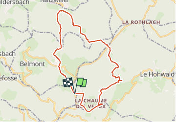

Length
16.7 km

Max alt
1103 m

Uphill gradient
873 m
Km-Effort
28 km

Min alt
581 m

Downhill gradient
871 m
Boucle
Yes
Creation date :
2025-02-21 16:33:59.362
Updated on :
2025-02-25 09:46:19.648
6h26
Difficulty : Difficult

FREE GPS app for hiking
 SityTrail
IGN / Geographical institutes
SityTrail Plus
The world is yours!
About
Trail Walking of 16.7 km to be discovered at Grand Est, Bas-Rhin, Bellefosse. This trail is proposed by geranimo.
Positioning
Country:
France
Region :
Grand Est
Department/Province :
Bas-Rhin
Municipality :
Bellefosse
Location:
Unknown
Start:(Dec)
Start:(UTM)
371857 ; 5361610 (32U) N.
Comments