


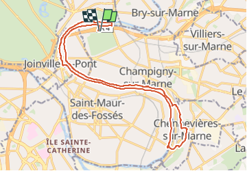
Rando - Bord de Marne - Nogent - Chennevieres 20km

jeanmarcMasson
User GUIDE

Length
20 km

Max alt
101 m

Uphill gradient
170 m
Km-Effort
23 km

Min alt
31 m

Downhill gradient
170 m
Boucle
Yes
Creation date :
2025-02-23 10:57:17.04
Updated on :
2025-02-23 11:03:26.281
5h06
Difficulty : Very difficult

FREE GPS app for hiking
 SityTrail
IGN / Geographical institutes
SityTrail Plus
The world is yours!
About
Trail Walking of 20 km to be discovered at Ile-de-France, Val-de-Marne, Champigny-sur-Marne. This trail is proposed by jeanmarcMasson.
Positioning
Country:
France
Region :
Ile-de-France
Department/Province :
Val-de-Marne
Municipality :
Champigny-sur-Marne
Location:
Unknown
Start:(Dec)
Start:(UTM)
462341 ; 5408576 (31U) N.
Comments