


T-JG-A53S La Sagittaire-Sucy

Jack-94
User
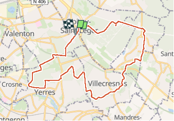

Length
22 km

Max alt
119 m

Uphill gradient
200 m
Km-Effort
24 km

Min alt
48 m

Downhill gradient
200 m
Boucle
Yes
Creation date :
2025-02-23 07:56:04.018
Updated on :
2025-02-23 17:38:15.756
6h37
Difficulty : Very difficult

FREE GPS app for hiking
 SityTrail
IGN / Geographical institutes
SityTrail Plus
The world is yours!
About
Trail Walking of 22 km to be discovered at Ile-de-France, Val-de-Marne, Limeil-Brévannes. This trail is proposed by Jack-94.

Positioning
Country:
France
Region :
Ile-de-France
Department/Province :
Val-de-Marne
Municipality :
Limeil-Brévannes
Location:
Unknown
Start:(Dec)
Start:(UTM)
463976 ; 5399030 (31U) N.
Comments