Ste Cécile d'Andorge (P1)

GOIOLIRIBES
User

Length
14.8 km

Max alt
629 m

Uphill gradient
429 m
Km-Effort
20 km

Min alt
286 m

Downhill gradient
430 m
Boucle
Yes
Creation date :
2025-02-23 15:19:45.904
Updated on :
2025-02-23 15:26:32.875
4h39
Difficulty : Medium

FREE GPS app for hiking
 SityTrail
IGN / Geographical institutes
SityTrail Plus
The world is yours!
About
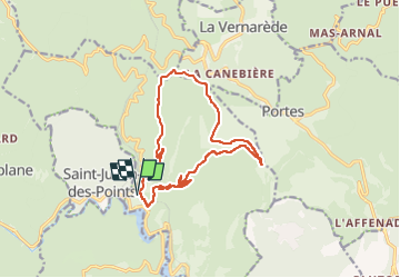
Trail On foot of 14.8 km to be discovered at Occitania, Gard, Sainte-Cécile-d'Andorge. This trail is proposed by GOIOLIRIBES.
Description
Départ de la Mairie/église. Villaret - Chalserre - Aubrac - Peyrérols (Les pinèdes)- Meymarède - Troubat.
Positioning
Country:
France
Region :
Occitania
Department/Province :
Gard
Municipality :
Sainte-Cécile-d'Andorge
Location:
Unknown
Start:(Dec)
Start:(UTM)
577922 ; 4900329 (31T) N.
Comments