


23/02/25 - Dorlisheim

delm
User
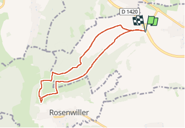

Length
7.6 km

Max alt
339 m

Uphill gradient
176 m
Km-Effort
10 km

Min alt
204 m

Downhill gradient
176 m
Boucle
Yes
Creation date :
2025-02-23 13:20:32.0
Updated on :
2025-02-23 15:34:34.857

FREE GPS app for hiking
 SityTrail
IGN / Geographical institutes
SityTrail Plus
The world is yours!
About
Trail of 7.6 km to be discovered at Grand Est, Bas-Rhin, Dorlisheim. This trail is proposed by delm.
Positioning
Country:
France
Region :
Grand Est
Department/Province :
Bas-Rhin
Municipality :
Dorlisheim
Location:
Unknown
Start:(Dec)
Start:(UTM)
386742 ; 5375645 (32U) N.
Comments