


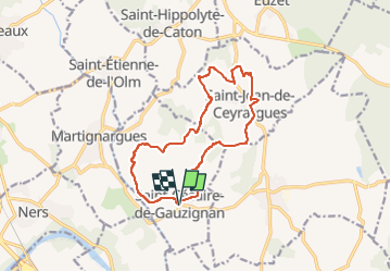
St Cézaire de Gauzignan - St Jean de Cérargues

GOIOLIRIBES
User

Length
14.7 km

Max alt
195 m

Uphill gradient
263 m
Km-Effort
18.2 km

Min alt
91 m

Downhill gradient
263 m
Boucle
Yes
Creation date :
2025-02-23 16:31:20.004
Updated on :
2025-02-23 16:33:00.741
4h07
Difficulty : Easy

FREE GPS app for hiking
 SityTrail
IGN / Geographical institutes
SityTrail Plus
The world is yours!
About
Trail On foot of 14.7 km to be discovered at Occitania, Gard, Saint-Césaire-de-Gauzignan. This trail is proposed by GOIOLIRIBES.
Description
Départ de la Mairie.
Positioning
Country:
France
Region :
Occitania
Department/Province :
Gard
Municipality :
Saint-Césaire-de-Gauzignan
Location:
Unknown
Start:(Dec)
Start:(UTM)
596593 ; 4875784 (31T) N.
Comments