Trail Walking Mons - Piste des aiguilles - Photo

Piste des aiguilles

© OpenStreetMap contributors
Length
Length
5.6 km
Max alt
Max alt
836 m
Uphill gradient
Uphill gradient
703 m
Km-Effort
Km-Effort  
13.9 km
Min alt
Min alt
196 m
Downhill gradient
Downhill gradient
380 m
Boucle
Boucle
No
Creation date :
2015-06-24 00:00:00.0
Updated on :
2015-06-24 00:00:00.0

(1 Reviews)

Walking
Walking
3h02
Difficulty : Very difficult

Scan this QR Code to open this trail in the SityTrail application

FREE GPS app for hiking

Logo SityTrail SityTrail

IGN / Geographical institutes

Download SityTrail from the App Store Download SityTrail from Google Play

Logo SityTrail SityTrail Plus

The world is yours!

Download SityTrail from the App Store Download SityTrail from Google Play Download SityTrail on Huawei AppGallery

About

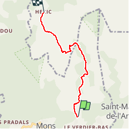
Trail Walking of 5.6 km to be discovered at Occitania, Hérault, Mons. This trail is proposed by gerardhenr.

Description

Du Verdier jusqu'au Rieutord montée mais moyen en difficultés. A partir de ce point plusieurs passages R4 (chaines) peur du vide s'abstenir! Marquage en rouge et cairns plus ou moins effacés par endroit. Retour du village d'Héric vers parking par piste bétonnée de 6 km. Superbes vues en plein massif du Caroux.

Elevation profile

Points of interest

Point of interest Rosis - Rieutord - Photo
gerardhenr
ROSIS 

Positioning

Country:
France
Region :
Occitania
Department/Province :
Hérault
Municipality :
Mons
Location:
Unknown
Start:(UTM)
497379 ; 4824520 (31T) N.

Comments

Please log in to post a review or rate the element


Le meilleurs sentier du caroux


Close
My subscriptions