


xp

raygautier
User
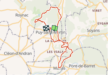

Length
20 km

Max alt
520 m

Uphill gradient
765 m
Km-Effort
30 km

Min alt
198 m

Downhill gradient
769 m
Boucle
Yes
Creation date :
2025-02-13 07:27:56.212
Updated on :
2025-02-24 17:58:15.512
7h55
Difficulty : Very difficult

FREE GPS app for hiking
 SityTrail
IGN / Geographical institutes
SityTrail Plus
The world is yours!
About
Trail Walking of 20 km to be discovered at Auvergne-Rhône-Alpes, Drôme, Puy-Saint-Martin. This trail is proposed by raygautier.
Positioning
Country:
France
Region :
Auvergne-Rhône-Alpes
Department/Province :
Drôme
Municipality :
Puy-Saint-Martin
Location:
Unknown
Start:(Dec)
Start:(UTM)
656551 ; 4943315 (31T) N.
Comments