


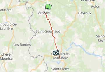
Arrênes-Chatelus plage

csy95
User

Length
10.6 km

Max alt
612 m

Uphill gradient
272 m
Km-Effort
14.5 km

Min alt
337 m

Downhill gradient
343 m
Boucle
No
Creation date :
2018-08-26 10:57:53.355
Updated on :
2018-08-26 10:57:53.372
3h02
Difficulty : Medium

FREE GPS app for hiking
 SityTrail
IGN / Geographical institutes
SityTrail Plus
The world is yours!
About
Trail Walking of 10.6 km to be discovered at New Aquitaine, Creuse, Arrènes. This trail is proposed by csy95.
Description
De Arrênes à la plage Chatelus le Marcheix
Positioning
Country:
France
Region :
New Aquitaine
Department/Province :
Creuse
Municipality :
Arrènes
Location:
Unknown
Start:(Dec)
Start:(UTM)
389429 ; 5102941 (31T) N.
Comments