


BM Boucle Brunoy Yerres 12km

jeanmarcMasson
User GUIDE
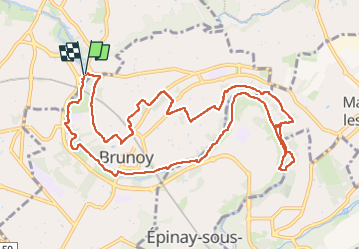

Length
12.1 km

Max alt
85 m

Uphill gradient
123 m
Km-Effort
13.8 km

Min alt
37 m

Downhill gradient
123 m
Boucle
Yes
Creation date :
2025-02-26 08:15:09.306
Updated on :
2025-02-26 16:34:47.76
2h41
Difficulty : Difficult

FREE GPS app for hiking
 SityTrail
IGN / Geographical institutes
SityTrail Plus
The world is yours!
About
Trail Walking of 12.1 km to be discovered at Ile-de-France, Essonne, Yerres. This trail is proposed by jeanmarcMasson.
Description
Départ parking des 2 rivière (derrière Mac Do)
Positioning
Country:
France
Region :
Ile-de-France
Department/Province :
Essonne
Municipality :
Yerres
Location:
Unknown
Start:(Dec)
Start:(UTM)
463030 ; 5395050 (31U) N.
Comments