


st lattier

philou68
User
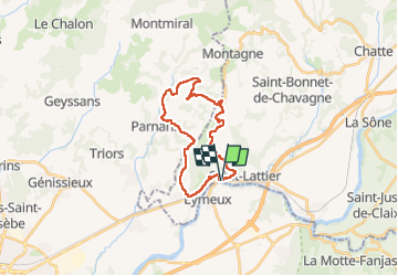

Length
22 km

Max alt
388 m

Uphill gradient
632 m
Km-Effort
30 km

Min alt
152 m

Downhill gradient
634 m
Boucle
Yes
Creation date :
2025-02-26 07:33:27.61
Updated on :
2025-02-26 14:49:18.619
7h15
Difficulty : Easy

FREE GPS app for hiking
 SityTrail
IGN / Geographical institutes
SityTrail Plus
The world is yours!
About
Trail Walking of 22 km to be discovered at Auvergne-Rhône-Alpes, Isère, Saint-Lattier. This trail is proposed by philou68.
Positioning
Country:
France
Region :
Auvergne-Rhône-Alpes
Department/Province :
Isère
Municipality :
Saint-Lattier
Location:
Unknown
Start:(Dec)
Start:(UTM)
672090 ; 4994792 (31T) N.
Comments