


boismont 27.02.2025

jcb48
User
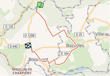

Length
5.4 km

Max alt
344 m

Uphill gradient
53 m
Km-Effort
6.2 km

Min alt
285 m

Downhill gradient
76 m
Boucle
No
Creation date :
2025-02-26 16:31:48.63
Updated on :
2025-02-26 16:33:32.228
1h24
Difficulty : Medium

FREE GPS app for hiking
 SityTrail
IGN / Geographical institutes
SityTrail Plus
The world is yours!
About
Trail Walking of 5.4 km to be discovered at Grand Est, Meurthe-et-Moselle, Boismont. This trail is proposed by jcb48.
Description
randonnée
Positioning
Country:
France
Region :
Grand Est
Department/Province :
Meurthe-et-Moselle
Municipality :
Boismont
Location:
Unknown
Start:(Dec)
Start:(UTM)
698775 ; 5477827 (31U) N.
Comments