


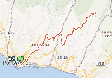
Mad_11_PontadoSol-SítioRibeirodaTabua

jeanmarcMasson
User GUIDE

Length
17.5 km

Max alt
458 m

Uphill gradient
913 m
Km-Effort
30 km

Min alt
20 m

Downhill gradient
913 m
Boucle
Yes
Creation date :
2025-02-27 08:15:39.703
Updated on :
2025-02-27 08:16:04.126
6h44
Difficulty : Very difficult

FREE GPS app for hiking
 SityTrail
IGN / Geographical institutes
SityTrail Plus
The world is yours!
About
Trail Walking of 17.5 km to be discovered at Madeira, Unknown, Ponta do Sol. This trail is proposed by jeanmarcMasson.
Points of interest


Positioning
Country:
Portugal
Region :
Madeira
Department/Province :
Unknown
Municipality :
Ponta do Sol
Location:
Unknown
Start:(Dec)
Start:(UTM)
302644 ; 3617745 (28S) N.
Comments