


bougnon/ roquerol

Michel DUBOIS
User
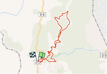

Length
9.7 km

Max alt
247 m

Uphill gradient
413 m
Km-Effort
15.2 km

Min alt
117 m

Downhill gradient
416 m
Boucle
Yes
Creation date :
2025-02-27 07:41:04.643
Updated on :
2025-02-27 11:12:32.775
2h33
Difficulty : Medium

FREE GPS app for hiking
 SityTrail
IGN / Geographical institutes
SityTrail Plus
The world is yours!
About
Trail Walking of 9.7 km to be discovered at Provence-Alpes-Côte d'Azur, Var, Roquebrune-sur-Argens. This trail is proposed by Michel DUBOIS.
Positioning
Country:
France
Region :
Provence-Alpes-Côte d'Azur
Department/Province :
Var
Municipality :
Roquebrune-sur-Argens
Location:
Unknown
Start:(Dec)
Start:(UTM)
311500 ; 4803795 (32T) N.
Comments