


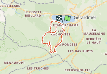
SityTrail - Cascade et tour de Merelle Gérardmer

geranimo
User

Length
11.6 km

Max alt
977 m

Uphill gradient
414 m
Km-Effort
17.1 km

Min alt
661 m

Downhill gradient
417 m
Boucle
Yes
Creation date :
2025-02-27 12:43:01.824
Updated on :
2025-02-27 12:44:26.207
3h52
Difficulty : Difficult

FREE GPS app for hiking
 SityTrail
IGN / Geographical institutes
SityTrail Plus
The world is yours!
About
Trail Walking of 11.6 km to be discovered at Grand Est, Vosges, Gérardmer. This trail is proposed by geranimo.
Positioning
Country:
France
Region :
Grand Est
Department/Province :
Vosges
Municipality :
Gérardmer
Location:
Unknown
Start:(Dec)
Start:(UTM)
340020 ; 5325725 (32U) N.
Comments