


lac du Miquelou Graulhet

tabouelle
User
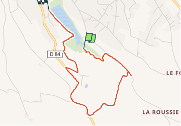

Length
4.4 km

Max alt
272 m

Uphill gradient
93 m
Km-Effort
5.6 km

Min alt
191 m

Downhill gradient
96 m
Boucle
No
Creation date :
2025-02-28 09:51:46.075
Updated on :
2025-02-28 11:36:36.76
1h44
Difficulty : Easy

FREE GPS app for hiking
 SityTrail
IGN / Geographical institutes
SityTrail Plus
The world is yours!
About
Trail Walking of 4.4 km to be discovered at Occitania, Tarn, Graulhet. This trail is proposed by tabouelle.
Positioning
Country:
France
Region :
Occitania
Department/Province :
Tarn
Municipality :
Graulhet
Location:
Unknown
Start:(Dec)
Start:(UTM)
419298 ; 4844035 (31T) N.
Comments