


VTT_Evan_04032025_25_9

d.rognon
User
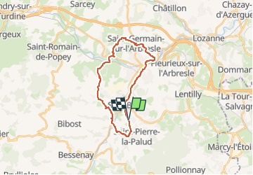

Length
23 km

Max alt
408 m

Uphill gradient
451 m
Km-Effort
29 km

Min alt
219 m

Downhill gradient
445 m
Boucle
Yes
Creation date :
2025-03-01 09:30:20.438
Updated on :
2025-03-01 09:43:45.274
2h00
Difficulty : Medium

FREE GPS app for hiking
 SityTrail
IGN / Geographical institutes
SityTrail Plus
The world is yours!
About
Trail Mountain bike of 23 km to be discovered at Auvergne-Rhône-Alpes, Rhône, Saint-Pierre-la-Palud. This trail is proposed by d.rognon.
Description
Boucle automatique Garmin
Positioning
Country:
France
Region :
Auvergne-Rhône-Alpes
Department/Province :
Rhône
Municipality :
Saint-Pierre-la-Palud
Location:
Unknown
Start:(Dec)
Start:(UTM)
624701 ; 5073103 (31T) N.
Comments