


![Trail Walking Gérardmer - Mauselaine - Tête de Grouvelin [Escargot blanc] - Photo](https://media.geolcdn.com/t/1900/400/9128f343-d92a-4ffa-a096-3ef82c8f639e.jpg&format=pjpeg&maxdim=2)
Mauselaine - Tête de Grouvelin [Escargot blanc]

Je vous emmène sur mes chemins
Par Mumu.larandonneuse


3h26
Difficulty : Difficult
3h26
Difficulty : Difficult

FREE GPS app for hiking
 SityTrail
IGN / Geographical institutes
SityTrail Plus
The world is yours!
About
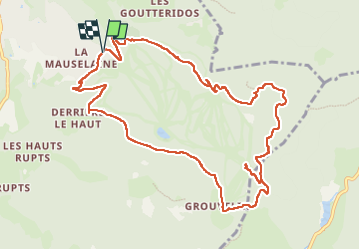
Trail Walking of 11.6 km to be discovered at Grand Est, Vosges, Gérardmer. This trail is proposed by Je vous emmène sur mes chemins .
Description
Boucle située au départ du domaine skiable alpin Gérardmer Stations. Itinéraire en accès libre balisé de 9 690 m (temps moyen estimé 4h30 à 5h). Circuit rouge. Une brochure est disponible à l'Office de Tourisme de Gérardmer et à l'accueil du domaine alpin et nordique Gérardmer Stations.
www.gerardmer.net/randos-et-balades-a-raquettes.php
.
Photos
![Trail Walking Gérardmer - Mauselaine - Tête de Grouvelin [Escargot blanc] - Photo 1](https://media.geolcdn.com/t/2048/auto/9128f343-d92a-4ffa-a096-3ef82c8f639e.jpg&format=jpg&maxdim=0 "Trail Walking Gérardmer - Mauselaine - Tête de Grouvelin [Escargot blanc] - Photo 1")
![Trail Walking Gérardmer - Mauselaine - Tête de Grouvelin [Escargot blanc] - Photo 2](https://media.geolcdn.com/t/2048/auto/b673e8a5-b3a5-42ff-ab46-3da0630a8592.jpg&format=jpg&maxdim=0 "Trail Walking Gérardmer - Mauselaine - Tête de Grouvelin [Escargot blanc] - Photo 2")
![Trail Walking Gérardmer - Mauselaine - Tête de Grouvelin [Escargot blanc] - Photo 3](https://media.geolcdn.com/t/2048/auto/88ecd975-9457-4c97-900a-61a7010d183d.jpg&format=jpg&maxdim=0 "Trail Walking Gérardmer - Mauselaine - Tête de Grouvelin [Escargot blanc] - Photo 3")
![Trail Walking Gérardmer - Mauselaine - Tête de Grouvelin [Escargot blanc] - Photo 4](https://media.geolcdn.com/t/2048/auto/4c0860fa-a107-45a3-89d6-9efb0203c805.jpg&format=jpg&maxdim=0 "Trail Walking Gérardmer - Mauselaine - Tête de Grouvelin [Escargot blanc] - Photo 4")
![Trail Walking Gérardmer - Mauselaine - Tête de Grouvelin [Escargot blanc] - Photo 5](https://media.geolcdn.com/t/2048/auto/86f06960-5eb2-46a2-83f8-edec602df73c.jpg&format=jpg&maxdim=0 "Trail Walking Gérardmer - Mauselaine - Tête de Grouvelin [Escargot blanc] - Photo 5")
![Trail Walking Gérardmer - Mauselaine - Tête de Grouvelin [Escargot blanc] - Photo 6](https://media.geolcdn.com/t/2048/auto/239bf190-d8e2-4a4e-97d1-7b4c8fa0edd9.jpg&format=jpg&maxdim=0 "Trail Walking Gérardmer - Mauselaine - Tête de Grouvelin [Escargot blanc] - Photo 6")
![Trail Walking Gérardmer - Mauselaine - Tête de Grouvelin [Escargot blanc] - Photo 7](https://media.geolcdn.com/t/2048/auto/d9c9f4b3-f4e7-4e38-8a24-f86ab6cde02c.jpg&format=jpg&maxdim=0 "Trail Walking Gérardmer - Mauselaine - Tête de Grouvelin [Escargot blanc] - Photo 7")
![Trail Walking Gérardmer - Mauselaine - Tête de Grouvelin [Escargot blanc] - Photo 8](https://media.geolcdn.com/t/2048/auto/457aa6a5-9745-4321-a26c-95b18985f4bb.jpg&format=jpg&maxdim=0 "Trail Walking Gérardmer - Mauselaine - Tête de Grouvelin [Escargot blanc] - Photo 8")
![Trail Walking Gérardmer - Mauselaine - Tête de Grouvelin [Escargot blanc] - Photo 9](https://media.geolcdn.com/t/2048/auto/daf1701d-4b41-4cdd-b63a-85d2cdae8cbc.jpg&format=jpg&maxdim=0 "Trail Walking Gérardmer - Mauselaine - Tête de Grouvelin [Escargot blanc] - Photo 9")
![Trail Walking Gérardmer - Mauselaine - Tête de Grouvelin [Escargot blanc] - Photo 10](https://media.geolcdn.com/t/2048/auto/09956c48-7765-4924-9fc8-5b73dd8be110.jpg&format=jpg&maxdim=0 "Trail Walking Gérardmer - Mauselaine - Tête de Grouvelin [Escargot blanc] - Photo 10")
![Trail Walking Gérardmer - Mauselaine - Tête de Grouvelin [Escargot blanc] - Photo 11](https://media.geolcdn.com/t/2048/auto/ef5548ae-4fd9-46e1-934a-9696114c928e.jpg&format=jpg&maxdim=0 "Trail Walking Gérardmer - Mauselaine - Tête de Grouvelin [Escargot blanc] - Photo 11")
![Trail Walking Gérardmer - Mauselaine - Tête de Grouvelin [Escargot blanc] - Photo 12](https://media.geolcdn.com/t/2048/auto/954afa52-05e0-4dd8-a6b2-73ce3f5f6ac6.jpg&format=jpg&maxdim=0 "Trail Walking Gérardmer - Mauselaine - Tête de Grouvelin [Escargot blanc] - Photo 12")
![Trail Walking Gérardmer - Mauselaine - Tête de Grouvelin [Escargot blanc] - Photo 13](https://media.geolcdn.com/t/2048/auto/ab88541f-846e-4135-8d79-87409ef10a14.jpg&format=jpg&maxdim=0 "Trail Walking Gérardmer - Mauselaine - Tête de Grouvelin [Escargot blanc] - Photo 13")
![Trail Walking Gérardmer - Mauselaine - Tête de Grouvelin [Escargot blanc] - Photo 14](https://media.geolcdn.com/t/2048/auto/ab80f0f9-2003-4206-a6d8-b2551bc28ad2.jpg&format=jpg&maxdim=0 "Trail Walking Gérardmer - Mauselaine - Tête de Grouvelin [Escargot blanc] - Photo 14")
![Trail Walking Gérardmer - Mauselaine - Tête de Grouvelin [Escargot blanc] - Photo 15](https://media.geolcdn.com/t/2048/auto/bb5b6b5c-3e84-4fcd-8fdb-9a0bc4bfd145.jpg&format=jpg&maxdim=0 "Trail Walking Gérardmer - Mauselaine - Tête de Grouvelin [Escargot blanc] - Photo 15")
![Trail Walking Gérardmer - Mauselaine - Tête de Grouvelin [Escargot blanc] - Photo 16](https://media.geolcdn.com/t/2048/auto/f60dbbc1-2db5-4aa2-b01a-feb343089ac1.jpg&format=jpg&maxdim=0 "Trail Walking Gérardmer - Mauselaine - Tête de Grouvelin [Escargot blanc] - Photo 16")
Positioning
Comments