


St Paul de Vence - la Sine

franquen
User
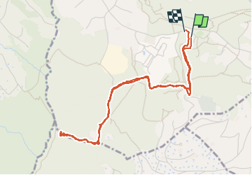

Length
5.5 km

Max alt
348 m

Uphill gradient
133 m
Km-Effort
7.2 km

Min alt
241 m

Downhill gradient
132 m
Boucle
Yes
Creation date :
2025-03-02 09:51:53.455
Updated on :
2025-03-02 13:26:22.745
1h50
Difficulty : Easy

FREE GPS app for hiking
 SityTrail
IGN / Geographical institutes
SityTrail Plus
The world is yours!
About
Trail Walking of 5.5 km to be discovered at Provence-Alpes-Côte d'Azur, Maritime Alps, Vence. This trail is proposed by franquen.
Description
lieu de promenade
Positioning
Country:
France
Region :
Provence-Alpes-Côte d'Azur
Department/Province :
Maritime Alps
Municipality :
Vence
Location:
Unknown
Start:(Dec)
Start:(UTM)
346639 ; 4841738 (32T) N.
Comments