


Rases Silord

michel8764
User
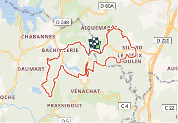

Length
11.4 km

Max alt
477 m

Uphill gradient
278 m
Km-Effort
15.1 km

Min alt
382 m

Downhill gradient
291 m
Boucle
No
Creation date :
2025-03-02 12:30:10.0
Updated on :
2025-03-02 15:23:28.053
2h40
Difficulty : Difficult

FREE GPS app for hiking
 SityTrail
IGN / Geographical institutes
SityTrail Plus
The world is yours!
About
Trail Walking of 11.4 km to be discovered at New Aquitaine, Haute-Vienne, Compreignac. This trail is proposed by michel8764.
Positioning
Country:
France
Region :
New Aquitaine
Department/Province :
Haute-Vienne
Municipality :
Compreignac
Location:
Unknown
Start:(Dec)
Start:(UTM)
369709 ; 5097490 (31T) N.
Comments