


st Beaume Resto

ericmestre
User
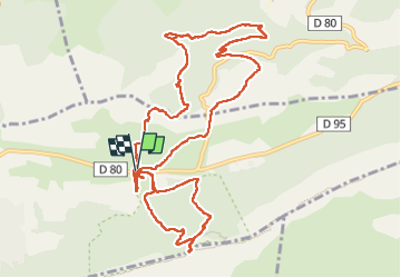

Length
15.2 km

Max alt
982 m

Uphill gradient
646 m
Km-Effort
24 km

Min alt
434 m

Downhill gradient
644 m
Boucle
Yes
Creation date :
2025-02-28 09:00:01.393
Updated on :
2025-03-02 19:11:02.125
5h34
Difficulty : Very difficult

FREE GPS app for hiking
 SityTrail
IGN / Geographical institutes
SityTrail Plus
The world is yours!
About
Trail Walking of 15.2 km to be discovered at Provence-Alpes-Côte d'Azur, Var, Plan-d'Aups-Sainte-Baume. This trail is proposed by ericmestre.
Positioning
Country:
France
Region :
Provence-Alpes-Côte d'Azur
Department/Province :
Var
Municipality :
Plan-d'Aups-Sainte-Baume
Location:
Unknown
Start:(Dec)
Start:(UTM)
723440 ; 4801825 (31T) N.
Comments