


VTT_Evan_04032025_18

d.rognon
User
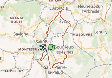

Length
17.6 km

Max alt
409 m

Uphill gradient
384 m
Km-Effort
23 km

Min alt
224 m

Downhill gradient
383 m
Boucle
Yes
Creation date :
2025-03-03 11:04:37.222
Updated on :
2025-03-03 11:05:22.757
1h34
Difficulty : Medium

FREE GPS app for hiking
 SityTrail
IGN / Geographical institutes
SityTrail Plus
The world is yours!
About
Trail Mountain bike of 17.6 km to be discovered at Auvergne-Rhône-Alpes, Rhône, Saint-Pierre-la-Palud. This trail is proposed by d.rognon.
Positioning
Country:
France
Region :
Auvergne-Rhône-Alpes
Department/Province :
Rhône
Municipality :
Saint-Pierre-la-Palud
Location:
Unknown
Start:(Dec)
Start:(UTM)
624683 ; 5073139 (31T) N.
Comments