


Lisseuil les Tinants Chateau Rocher 22 km 800 m dènivelè

jeanic63
User
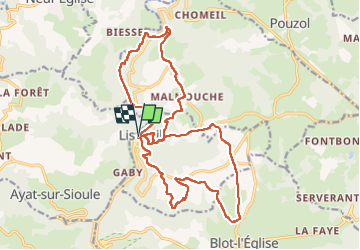

Length
22 km

Max alt
633 m

Uphill gradient
801 m
Km-Effort
33 km

Min alt
362 m

Downhill gradient
799 m
Boucle
Yes
Creation date :
2025-03-03 07:32:57.597
Updated on :
2025-03-05 17:45:38.157
7h24
Difficulty : Very difficult

FREE GPS app for hiking
 SityTrail
IGN / Geographical institutes
SityTrail Plus
The world is yours!
About
Trail Walking of 22 km to be discovered at Auvergne-Rhône-Alpes, Puy-de-Dôme, Lisseuil. This trail is proposed by jeanic63.
Description
départ parking lisseuil
Positioning
Country:
France
Region :
Auvergne-Rhône-Alpes
Department/Province :
Puy-de-Dôme
Municipality :
Lisseuil
Location:
Unknown
Start:(Dec)
Start:(UTM)
493684 ; 5101058 (31T) N.
Comments