


st cyprien, entre mer et étang

stef789
User GUIDE
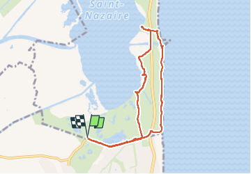

Length
8.7 km

Max alt
4 m

Uphill gradient
14 m
Km-Effort
8.9 km

Min alt
-4 m

Downhill gradient
14 m
Boucle
Yes
Creation date :
2025-03-03 14:00:18.457
Updated on :
2025-03-03 17:07:58.727
3h07
Difficulty : Very easy

FREE GPS app for hiking
 SityTrail
IGN / Geographical institutes
SityTrail Plus
The world is yours!
About
Trail Walking of 8.7 km to be discovered at Occitania, Pyrénées-Orientales, Canet-en-Roussillon. This trail is proposed by stef789.
Photos


28 photos in total. Please click on a photo to see them all in the gallery.
Positioning
Country:
France
Region :
Occitania
Department/Province :
Pyrénées-Orientales
Municipality :
Canet-en-Roussillon
Location:
Unknown
Start:(Dec)
Start:(UTM)
501412 ; 4720846 (31T) N.
Comments