


R1T-A53S-Autour de Coquibus

Jack-94
User
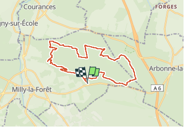

Length
16.6 km

Max alt
137 m

Uphill gradient
286 m
Km-Effort
20 km

Min alt
72 m

Downhill gradient
288 m
Boucle
Yes
Creation date :
2025-03-04 08:43:35.502
Updated on :
2025-03-04 20:23:53.749
5h21
Difficulty : Very difficult

FREE GPS app for hiking
 SityTrail
IGN / Geographical institutes
SityTrail Plus
The world is yours!
About
Trail Walking of 16.6 km to be discovered at Ile-de-France, Essonne, Milly-la-Forêt. This trail is proposed by Jack-94.

Positioning
Country:
France
Region :
Ile-de-France
Department/Province :
Essonne
Municipality :
Milly-la-Forêt
Location:
Unknown
Start:(Dec)
Start:(UTM)
463571 ; 5361523 (31U) N.
Comments