


SityTrail - Glaine-Montaigut

jeanic63
User

Length
21 km

Max alt
520 m

Uphill gradient
454 m
Km-Effort
27 km

Min alt
344 m

Downhill gradient
457 m
Boucle
Yes
Creation date :
2025-03-06 09:38:21.589
Updated on :
2025-03-11 17:52:45.084
6h09
Difficulty : Medium

FREE GPS app for hiking
 SityTrail
IGN / Geographical institutes
SityTrail Plus
The world is yours!
About
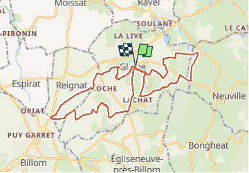
Trail On foot of 21 km to be discovered at Auvergne-Rhône-Alpes, Puy-de-Dôme, Glaine-Montaigut. This trail is proposed by jeanic63.
Description
huit, départ parking cimetière
Positioning
Country:
France
Region :
Auvergne-Rhône-Alpes
Department/Province :
Puy-de-Dôme
Municipality :
Glaine-Montaigut
Location:
Unknown
Start:(Dec)
Start:(UTM)
530309 ; 5066984 (31T) N.
Comments