


marais-de-stors-v2

jpcccb
User
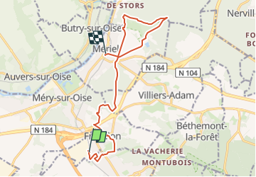

Length
12.8 km

Max alt
141 m

Uphill gradient
173 m
Km-Effort
15.2 km

Min alt
33 m

Downhill gradient
223 m
Boucle
No
Creation date :
2025-03-06 10:21:43.583
Updated on :
2025-06-01 09:32:32.939
3h27
Difficulty : Difficult

FREE GPS app for hiking
 SityTrail
IGN / Geographical institutes
SityTrail Plus
The world is yours!
About
Trail Walking of 12.8 km to be discovered at Ile-de-France, Val-d'Oise, Frépillon. This trail is proposed by jpcccb.
Positioning
Country:
France
Region :
Ile-de-France
Department/Province :
Val-d'Oise
Municipality :
Frépillon
Location:
Unknown
Start:(Dec)
Start:(UTM)
441316 ; 5432915 (31U) N.
Comments