


Nançon,forairie,chenedet 12,5km.Pascal

COGLAIS3
User
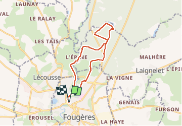

Length
12.4 km

Max alt
174 m

Uphill gradient
183 m
Km-Effort
14.9 km

Min alt
104 m

Downhill gradient
183 m
Boucle
Yes
Creation date :
2025-03-06 08:02:22.583
Updated on :
2025-03-07 08:48:24.092
2h25
Difficulty : Very easy

FREE GPS app for hiking
 SityTrail
IGN / Geographical institutes
SityTrail Plus
The world is yours!
About
Trail Nordic walking of 12.4 km to be discovered at Brittany, Ille-et-Vilaine, Fougères. This trail is proposed by COGLAIS3.
Positioning
Country:
France
Region :
Brittany
Department/Province :
Ille-et-Vilaine
Municipality :
Fougères
Location:
Unknown
Start:(Dec)
Start:(UTM)
633170 ; 5357560 (30U) N.
Comments