


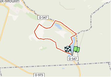
007rd etangs st pierre

tine60
User

Length
5.6 km

Max alt
85 m

Uphill gradient
58 m
Km-Effort
6.4 km

Min alt
48 m

Downhill gradient
58 m
Boucle
Yes
Creation date :
2025-03-06 13:25:19.256
Updated on :
2025-03-06 15:01:06.32
1h23
Difficulty : Medium

FREE GPS app for hiking
 SityTrail
IGN / Geographical institutes
SityTrail Plus
The world is yours!
About
Trail Walking of 5.6 km to be discovered at Hauts-de-France, Oise, Vieux-Moulin. This trail is proposed by tine60.
Positioning
Country:
France
Region :
Hauts-de-France
Department/Province :
Oise
Municipality :
Vieux-Moulin
Location:
Unknown
Start:(Dec)
Start:(UTM)
497601 ; 5468949 (31U) N.
Comments