


Rambouillet 19 avril 25

mouchette94
User
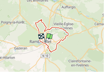

Length
22 km

Max alt
187 m

Uphill gradient
202 m
Km-Effort
25 km

Min alt
147 m

Downhill gradient
203 m
Boucle
Yes
Creation date :
2025-03-07 10:19:32.223
Updated on :
2025-03-07 10:20:46.017
5h35
Difficulty : Medium

FREE GPS app for hiking
 SityTrail
IGN / Geographical institutes
SityTrail Plus
The world is yours!
About
Trail On foot of 22 km to be discovered at Ile-de-France, Yvelines, Rambouillet. This trail is proposed by mouchette94.
Positioning
Country:
France
Region :
Ile-de-France
Department/Province :
Yvelines
Municipality :
Rambouillet
Location:
Unknown
Start:(Dec)
Start:(UTM)
413909 ; 5388472 (31U) N.
Comments