


Tour de Boran le Lys

avdem
User
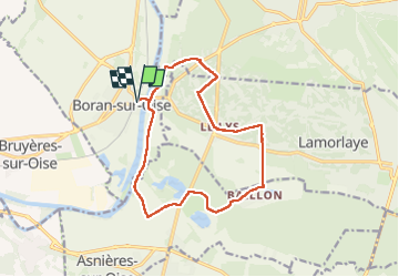

Length
13.3 km

Max alt
49 m

Uphill gradient
93 m
Km-Effort
14.5 km

Min alt
23 m

Downhill gradient
93 m
Boucle
Yes
Creation date :
2025-03-11 08:29:46.214
Updated on :
2025-03-11 11:54:32.654
3h23
Difficulty : Easy

FREE GPS app for hiking
 SityTrail
IGN / Geographical institutes
SityTrail Plus
The world is yours!
About
Trail Walking of 13.3 km to be discovered at Hauts-de-France, Oise, Boran-sur-Oise. This trail is proposed by avdem.
Description
Facile
Positioning
Country:
France
Region :
Hauts-de-France
Department/Province :
Oise
Municipality :
Boran-sur-Oise
Location:
Unknown
Start:(Dec)
Start:(UTM)
453628 ; 5446324 (31U) N.
Comments