


SityTrail - Fleury devant douaumont_Champs_de_bataille_de_Verdun

ZAMBAUX
User
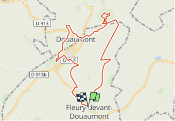

Length
9 km

Max alt
391 m

Uphill gradient
160 m
Km-Effort
11.1 km

Min alt
301 m

Downhill gradient
162 m
Boucle
Yes
Creation date :
2025-03-12 16:14:42.708
Updated on :
2025-03-12 16:16:29.845
2h31
Difficulty : Medium

FREE GPS app for hiking
 SityTrail
IGN / Geographical institutes
SityTrail Plus
The world is yours!
About
Trail Walking of 9 km to be discovered at Grand Est, Meuse, Fleury-devant-Douaumont. This trail is proposed by ZAMBAUX.
Description
Marche facile
Positioning
Country:
France
Region :
Grand Est
Department/Province :
Meuse
Municipality :
Fleury-devant-Douaumont
Location:
Unknown
Start:(Dec)
Start:(UTM)
677232 ; 5452043 (31U) N.
Comments