


2025 03 Fontainebleau t1

michel1025
User
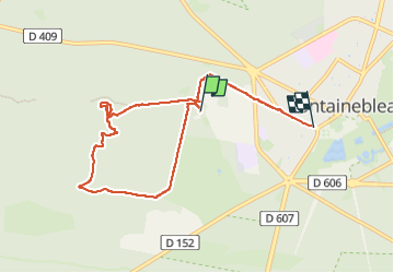

Length
7.5 km

Max alt
133 m

Uphill gradient
108 m
Km-Effort
9 km

Min alt
77 m

Downhill gradient
113 m
Boucle
No
Creation date :
2025-03-13 09:13:49.0
Updated on :
2025-03-13 12:50:15.615
3h36
Difficulty : Medium

FREE GPS app for hiking
 SityTrail
IGN / Geographical institutes
SityTrail Plus
The world is yours!
About
Trail Walking of 7.5 km to be discovered at Ile-de-France, Seine-et-Marne, Fontainebleau. This trail is proposed by michel1025.
Positioning
Country:
France
Region :
Ile-de-France
Department/Province :
Seine-et-Marne
Municipality :
Fontainebleau
Location:
Unknown
Start:(Dec)
Start:(UTM)
476200 ; 5361291 (31U) N.
Comments