


rando estterel
© OpenStreetMap contributors


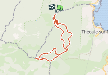
3h50
Difficulty : Medium


Length
9.4 km
Max alt
437 m
Uphill gradient
419 m
Km-Effort
15 km
Min alt
67 m
Downhill gradient
422 m
Boucle
Yes
Creation date :
2025-03-13 09:01:39.028
Updated on :
2025-03-13 16:30:56.437
3h50
Difficulty : Medium
FREE GPS app for hiking
 SityTrail
IGN / Geographical institutes
SityTrail Plus
The world is yours!
About
Trail Walking of 9.4 km to be discovered at Provence-Alpes-Côte d'Azur, Maritime Alps, Théoule-sur-Mer. This trail is proposed by Denis Danielle Berthier.
Description
rando
Positioning
Country:
France
Region :
Provence-Alpes-Côte d'Azur
Department/Province :
Maritime Alps
Municipality :
Théoule-sur-Mer
Location:
Unknown
Start:(Dec)
Start:(UTM)
331535 ; 4819923 (32T) N.
Comments