


villebichot

RM21700
User
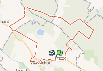

Length
12.8 km

Max alt
240 m

Uphill gradient
105 m
Km-Effort
14.2 km

Min alt
198 m

Downhill gradient
105 m
Boucle
Yes
Creation date :
2025-01-23 12:59:50.471
Updated on :
2025-03-14 09:41:10.54
2h45
Difficulty : Difficult

FREE GPS app for hiking
 SityTrail
IGN / Geographical institutes
SityTrail Plus
The world is yours!
About
Trail Walking of 12.8 km to be discovered at Bourgogne-Franche-Comté, Côte-d'Or, Villebichot. This trail is proposed by RM21700.
Positioning
Country:
France
Region :
Bourgogne-Franche-Comté
Department/Province :
Côte-d'Or
Municipality :
Villebichot
Location:
Unknown
Start:(Dec)
Start:(UTM)
655563 ; 5222918 (31T) N.
Comments