


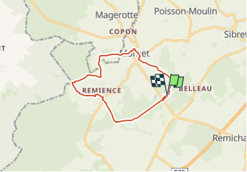
morhet a partir du gite de la chapelel

nico_be
User

Length
11 km

Max alt
538 m

Uphill gradient
173 m
Km-Effort
13.3 km

Min alt
460 m

Downhill gradient
172 m
Boucle
Yes
Creation date :
2025-03-14 18:13:31.57
Updated on :
2025-03-14 18:13:33.86
3h01
Difficulty : Difficult

FREE GPS app for hiking
 SityTrail
IGN / Geographical institutes
SityTrail Plus
The world is yours!
About
Trail Walking of 11 km to be discovered at Wallonia, Luxembourg, Vaux-sur-Sûre. This trail is proposed by nico_be.
Positioning
Country:
Belgium
Region :
Wallonia
Department/Province :
Luxembourg
Municipality :
Vaux-sur-Sûre
Location:
Nives
Start:(Dec)
Start:(UTM)
686581 ; 5536091 (31U) N.
Comments